Consultation has now closed. Thank you to those who provided feedback. Further updates will be provided here in line with community feedback.
Help us improve your local walks
Council is reviewing our Principal Pedestrian Network and we are seeking feedback on a new aspirational network map and the priority areas.Council is committed to creating neighbourhoods that are walkable, connected, and vibrant for everyone, as outlined in the Maroondah Transport Strategy 2025–2035.
To support this commitment, we are reviewing the Maroondah Principal Pedestrian Network (PPN). This review is a strategic response to the growing number of people walking, the need to overcome barriers to walking, and our goal to make walking in Maroondah safer and more enjoyable.
Our updated draft PPN presents an aspirational vision for safer, more accessible, and more enjoyable streets - helping people reach important destinations, connect with others, and enjoy recreation close to home.
It’s important to note that the Principal Pedestrian Network review is distinct from the Bicycle Network Plan. The PPN focuses exclusively on foot traffic - people walking, those using mobility aids, or people with prams. While both networks sometimes share facilities such as trails and shared pathways, the goals, priorities, and design principles for each network are developed independently to best support their specific users.
The PPN is underpinned by twelve principles:
- High Pedestrian Demand - All streets in activity centres will be considered primary routes, aiming for footpaths on both sides where practical (may be staged).
- Leverage Road Projects - When road upgrades are planned in PPN streets, footpaths and safety improvements will be considered simultaneously.
- Network Connectivity - New footpaths will be connected to the existing PPN to improve network coverage and ease of movement.
- Project-Specific Design - Wider or shared pathways may be introduced in areas with high demand, safety, or access concerns.
- Community Engagement - Local demand and public feedback will inform the planning and design of footpaths.
- Permeability and Safety - Efforts will focus on providing well-located, safe pedestrian crossings across major roads.
- Interesting Walking Experience - In heritage, cultural, and natural areas, the network will highlight scenic views, architectural features, and public art.
- Preservation - Footpath design/construction will aim to minimise impacts on the natural, built, and cultural environment.
- Amenity - The PPN will be maintained to high standards, with street tree planting coordinated alongside footpath construction.
- Equity - The footpath program will ensure fair access and distribution of works across the municipality.
- Legacy - Existing PPN pathways (established since 2009) will be retained in the updated network.
- Public Asset Focus - Improvements apply only to public land. Private streets or common property are excluded.
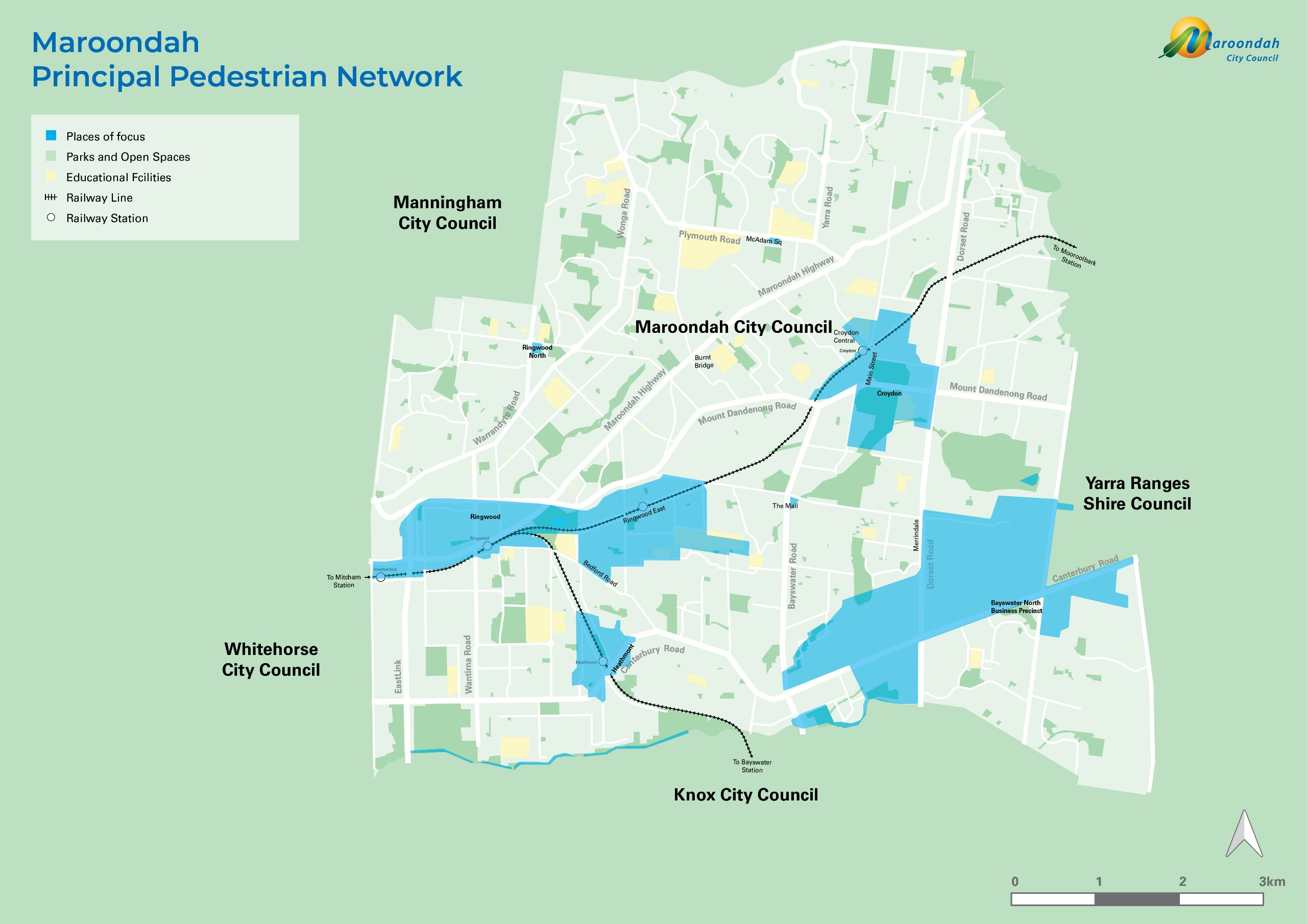
The review applies a 'node' and 'corridor' approach to ensure the PPN will link all parts of Maroondah by focusing on important nodes (centres of activity) and connecting corridors (major pathways, roads, and rail lines).
Key activity centres (nodes):
- Ringwood Metropolitan Activity Centre
- Bayswater Business Precinct
- Croydon Major Activity Centre
- Ringwood East, Heathmont, and Ringwood North Neighbourhood Centres
- Burnt Bridge, McAdam Square, Eastfield, and Bedford Road Shops
Key routes (corridors):
Road, streets, trails, or alleyways linking places in activity centres via gateways such as train stations, bus stops, or car parks.
Primary routes (high use)
Primary routes are the backbone of the PPN, designed to support the highest levels of pedestrian movement. These routes receive the highest priority for upgrades and new walking infrastructure, making them a major focus for future improvements.
Secondary routes (medium use)
Secondary routes play a key supporting role to the primary routes. They are assigned a medium level of pedestrian priority and service, enabling significant pedestrian movement. These routes will also be a focus for future infrastructure projects.
Tertiary routes
Tertiary routes connect local residential areas to the primary and secondary routes. They provide essential local links and are assigned a level of priority and service below secondary routes.
Special routes
Special routes are designated for specific purposes, such as school routes or important connections between other routes on the network. Even if they have lower pedestrian activity, these routes are given a medium level of priority and service, and will be a secondary focus for future infrastructure works.
Streets
View an alphabetical list of streets included on the draft Principal Pedestrian Network.
Thanks for having your say
Whether you’re an older resident, a parent with a pram, someone with limited mobility, a student, or simply enjoy walking - help us build a network that truly supports our diverse community.
By sharing your thoughts, you will help us prioritise improvements that make it easier and safer for everyone to walk to shops, schools, parks, public transport, and other key places. Together, we can create a more walkable Maroondah that supports health, social connection, and local living.
- Complete the short survey.
- Look up your address and make a comment on the interactive map.
Further information
If you would like further information about this project, please call us on 1300 88 22 33 or 9298 4598 or email maroondah@maroondah.vic.gov.au.


